World Water Day series – Post by Dr Andrew Black
“Accelerating change” is the theme for World Water Day 2023. Quoting the WWD organisers, “billions of people and countless schools, businesses, healthcare centres, farms and factories are being held back because their human rights to water and sanitation have not yet been fulfilled”. Against this backdrop, it’s surprising that the availability of water in many parts of the world is often poorly known: it’s much clearer to know when water is insufficient, or of poor quality, than to know in absolute terms how much is present. After all, water is continually varying in its quantities in groundwater, soil water, ice caps, glaciers, lakes and rivers, as well as showing considerable variations in space, sometimes even over short distances.
Nevertheless, there are many benefits in quantifying water resources, even if doing so is difficult. In fact, in our world of rapidly growing population and rising per capita demands, and against a backdrop of increasing environmental change, it has never been more important. This article examines some of the ways in which staff and students in Dundee are involved in quantifying water and other dimensions of the environment, considers why it’s important and where this work needs to go in the coming years.
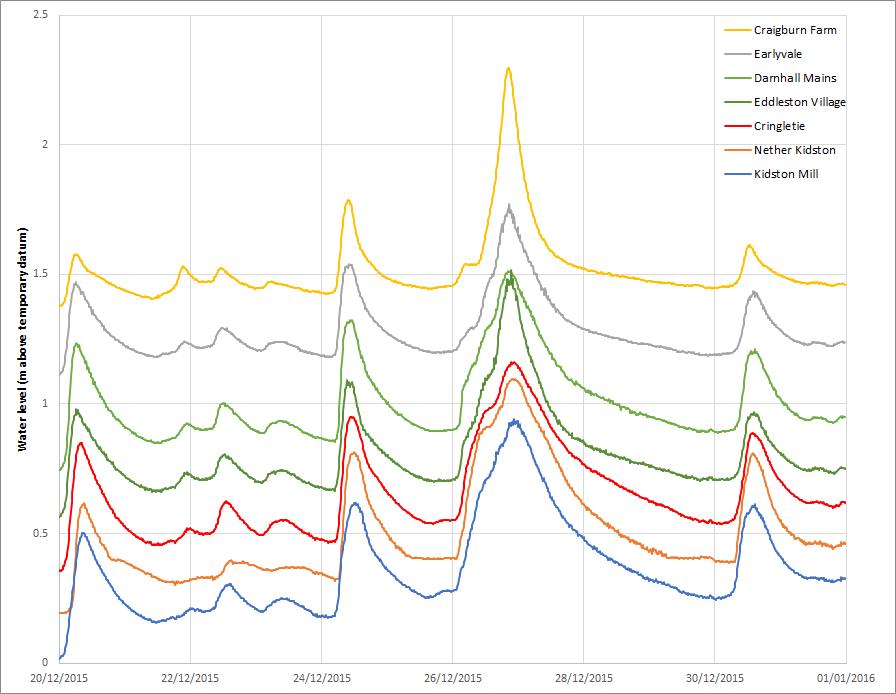
At Eddleston in the Scottish Borders, our long-running natural flood management (NFM) project relies on a dense network of rainfall and water level monitoring in order to understand hydrological response to rainfall and snowmelt, and to detect change. The main stem of the river, at 12 km in length, now has 10 river level gauges, which together allow propagation of flood waves to be studied (Fig. 1). Unexpected results have been identified, with river levels peaking at upstream sites after downstream sites – an effect not usually visible in a catchment served by only a single gauge at the catchment outlet. Another surprise is the tendency for many of the largest flood events to be partly caused by snowmelt. We are working with the project managers to target tributaries which would benefit most from NFM interventions. The strongly empirical and detailed focus of our research to date differentiates our work from other studies.
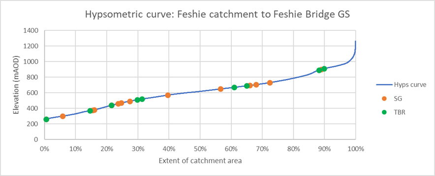
For water resources studies, mean annual rainfall is routinely required, but most gauges have always been located in lowland and valley bottom locations. Catchment-averaged rainfall inputs require knowledge of water inputs on the high ground as well as low, and this against a backdrop of expected increases in the westerly component of north European airflows and studies indicating that the rate of climate change in the mountains is accelerating. Reservoir safety assessments and water resource planning need to be informed by the best available information about precipitation in the mountains. Assumptions made regarding the rate of increase of precipitation with elevation may prove to be unsafe under climate change.
In Dundee we operate 10 recording rain gauges at sites above 400 metres elevation, the same number as SEPA, Scotland’s national hydrometric agency do nationally, while our 7 rain gauges above 500 m out-number SEPA’s 4. Many of these gauges are in Glen Feshie, where our rainfall monitoring has been designed to represent the full range of catchment elevations so far as practical considerations allow (Fig. 2), allowing corrections to be made to rainfall estimates.
There are ecological reasons to focus on the hydrology of these mountains as well as resource planning reasons. Our mountains are our water towers, yielding more water per unit area than anywhere else, and yielding delayed runoff from snowmelt in spring, maintaining low river water temperatures and elevated flows through the often dry months of April and May. Terrestrial environments in the mountains provide habitats for endangered species; multiple aspects of climate impact on their population health.
With a monitoring network which measures more than 15,000 observations every day, there is a danger of being inundated with data. Can there possibly be too much? One thing that stands out from my experience monitoring the environment over the years has been that we can never foresee all the uses which might arise for our data: often uses emerge which had not been anticipated when instruments were first installed. In Glen Feshie, we originally installed our network for the purpose of understanding how hydrological processes at one scale relate to behaviours at another. But in the subsequent 20 years, the estate has changed hands, with the new owner, Anders Holch Povlsen being committed to landscape-scale rewilding, with the Feshie catchment being at the heart of his plans. As woodland regeneration continues and is supplemented by targeted ditch blocking, tree planting and restoration of peat hags, we now have the underpinnings of a longitudinal study.
In a country often perceived as being wet, it is perhaps unsurprising that domestic water consumption is not metered, even though this practice is now widespread in many other (generally drier) parts of the UK. And yet, in 2022 Scotland saw its first-ever application of water abstraction controls since the implementation of the Water Framework Directive, following a dry spring and summer, illustrating that water shortage does occur. With climate change, the risks of shortage are expected to increase. Knowledge is power; the benefits of having quantitative information about water usage would apply equally in Scotland as elsewhere.
Monitoring the water environment gives our students the opportunity to undertake practical learning, be engaged with events as they occur, and helps extend the knowledge base which is sure to be used in years to come for assessments of climate change, water resources, flood risks and more. Digital technology allows data to be seen in real time, which allows water users – that’s all of us – to better understand our environment and take informed decisions relating to water today and in the future. Real-time data from our monitoring network can be found at https://hydro-data.dundee.ac.uk/